


The Chinese "Dragon Dance" features a flowing, abstracted dragon held aloft by multiple people supporting it overhead on poles. This flowing, animated form becomes the initial inspiration for the bridge which also refers to the nearby "Dragon's Back Trail" and the hilly topography of Hong Kong Island.
A proposal for a new piece of "mixed-use" infrastructure for Hong Kong's Tai Tam District. Click on the image to view the web video.
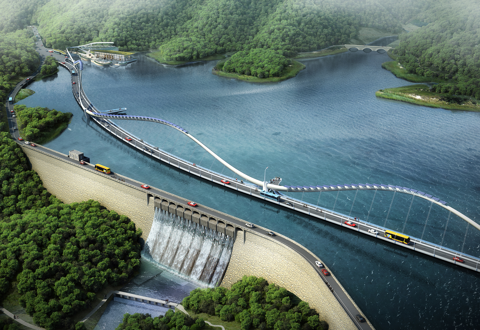
The new bridge design stands in contrast to the existing dam which will be 100 years old in February of 2018. It's intended to compliment the historically designated dam as a modern answer to the challenges and demands of today that didn't exist in 1918: road congestion, population growth, over-sized vehicles, hikers and cyclists.
The bridge will be animated with subtle LED controlled color changing lighting in addition to road illumination. Careful design consideration will be given to control light levels and energy consumption.
The dam is a massive solid structure designed in a heavy colonial style. This becomes the character foil to the new modern, minimal bridge design. The new steel arched bridge structure will preserve views to the hills across the reservoir through it's cable support system.
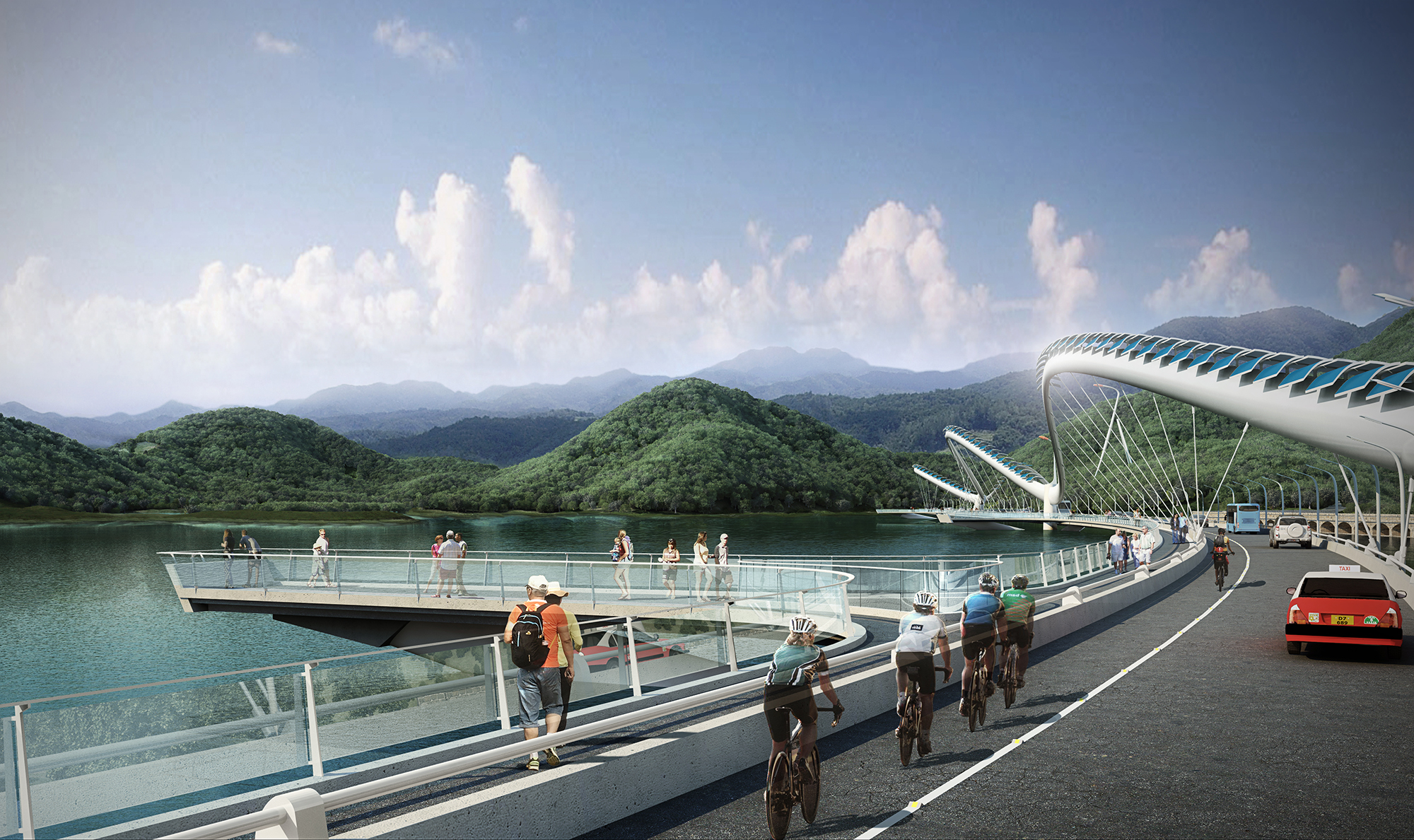
The 3 scenic overlook points are strategically located along the lenght of the walking path to capture composed views of the landscape around the reservoir. The central overlook in this view is aimed at another historic structure on the opposite side of the water - the Masonry "Three Arch Bridge". On the road, vehicles and cyclists get their own lanes.
Hong Kong has many different weather conditions, including frequent and heavy rainfall. The architectural lighting is designed to heighten the experience of the different weather events and provide an ever changing look and feel to the crossing.
The existing bathrooms and taxi drop-off area are inadequate, poorly designed and unattractive and also block the views from the road into the reservoir. The new design will provide a shady outdoor plaza for people to meet friends and embark on a hike or wait for a ride at the new taxi and bus drop-off.
The new pavilion will provide a community space for events and an outdoor area to be on the water with views to the surrounding hills. It will also have a space for a Cafe and Visitor Center focused on the Tai Tam District's history as well as current events in happening in the area.
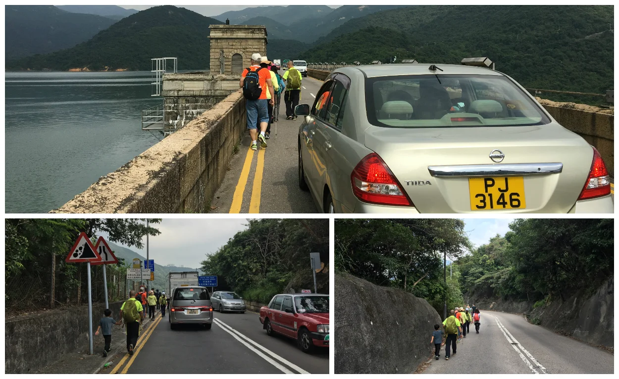
A recent heavy rainfall event caused significant flooding on the dam leading to a complete closure of the road.
On the left: A taxi driver recently attempted a "15-point Turn" in the middle of the damn resulting in blocking traffic in both directions. The event was covered in the local media.
On the right: When two large vehicles meet on the dam traffic comes to a complete standstill.
A group of hikers decides to make the dangerous walk across the dam. Traffic slows to avoid them and becomes congested.
Large groups of people often arrive by bus to embark on a hike creating traffic issues and unsafe driving conditions as vehicles become backed up and delayed.
On the left: The existing taxi stand is undersized and unattractive.
On the right: The view at the southern approach to the site is an old building containing public restrooms. The area is often overwhelmed by large hiking groups being dropped off and picked up with no space for people to queue.
On the left: The existing public restrooms block the view to the reservoir. The public space is too small to meet the demands of hikers and tourists visiting the area.
On the right: The new plaza and drop off area opens views to the water and creates a pleasant place to meet friends and wait for a ride.
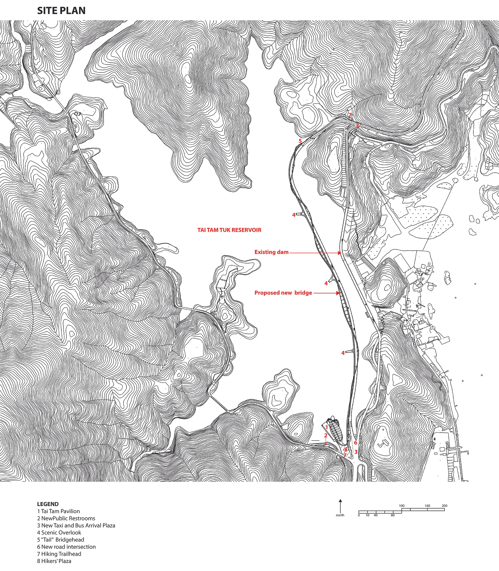
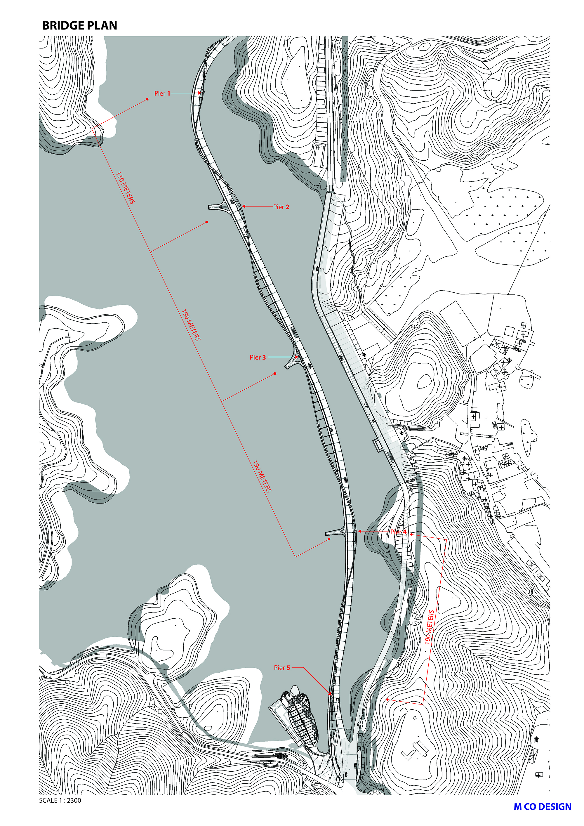
The new bridge is structurally designed to minimize the number of support points in the reservoir for ease of construction as well as water and environmental protection. The alignment utilizes a natural ravine and water control channel at the north to avoid unnecessary excavation of the topography. At the south, a new arrival and drop-off plaza for taxis, buses and cars creates a grand outdoor space.
The new bridge will carry one-way northbound traffic while the existing dam will become a one-way road for southbound vehicles. Cyclists will have a dedicated lane for improved traffic flow and road safety.
The new bridge will complete a missing link in the existing network of hiking trails. This will alleviate the current situation where hikers make a dangerous trek across the dam mixed in with traffic on a narrow roadway. The 5 km Heritage Trail will also become a complete loop that will be illuminated for night hiking with power provided by the bridge's photo-voltaic solar panels.
The planning of the new bridge will roughly parallel the old dam with support piers located to divide the spans efficiently. The existing approach to the dam at the south will be regraded to create more gentle curves in the road to improve traffic flow and safety.
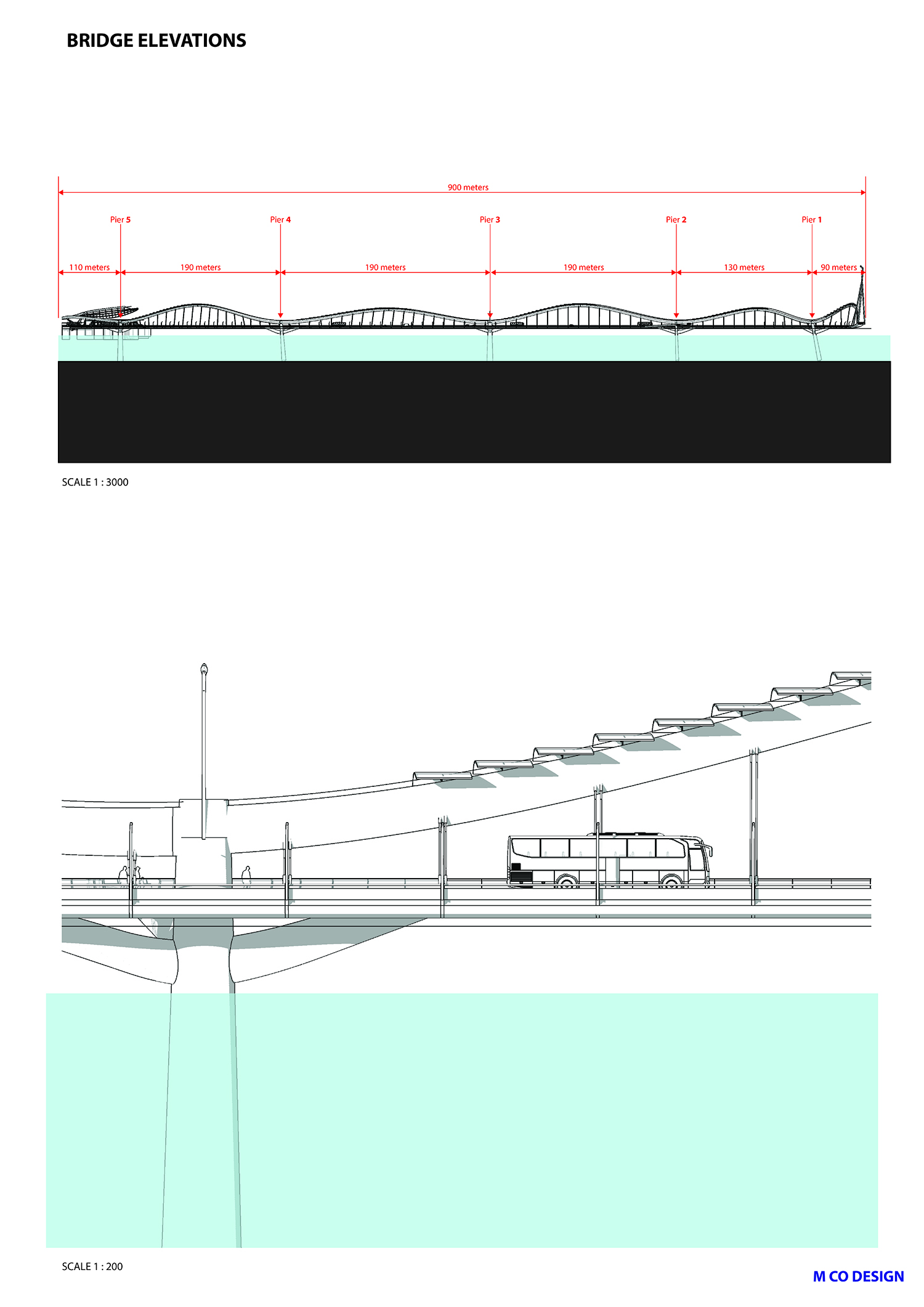
Pedestrians, vehicles and cyclists all have their own space for efficient movement. The pedestrian walkway is placed on the western side of the new bridge for maximum views to the water and features 3 scenic overlook points to allow for people to pause and contemplate the landscape.
A new pavilion with terraces overlooking the water will provide a community space for art openings, weddings, corporate events and other activities. A cafe and Tai Tam history exhibit will also be part of the pavilion. A series of terraces will step down to the water for outdoor dining and will also serve as break out areas for events. A large floating glass canopy overhead will provide shading and rain protection for part of the terrace areas.
The main bridge structure forms a ribbon-like flowing line supporting the roadway below. This is a reference to the hilly topography of Hong Kong Island and metaphorically linked to the local traditional "dragon dance". Photo-voltaic panels cladding the superstructure will provide power for the bridge lighting and also illuminate the Heritage Trail loop for night time hikes.
The overall length of the bridge is approximately 900 meters and is carried on 3 primary support piers.
A shorter alignment of the design is possible. This study is approximately 1/3 shorter in length than the original concept (450 meters versus 900 meters), otherwise it utilizes the same traffic flow patterns and pedestrian links including the scenic overlooks over the reservoir. The other site amenities also remain in the design. The pier placement also proposes that only one support point would be needed inside the water area. The other two support points are on land.
This study proposes that the connection happen over the land side and open gorge to the east of the existing dam. The length of this design is 1/3 the length (300 meters) of the original proposal. This alignment avoids the need for any pier supports over the reservoir water. It proposes a two way traffic flow over the new bridge connecting into the existing roads and dedicates the old dam solely to pedestrians and hikers. A new trail connection around the reservoir at the north would connect the hikers from the dam to the Hong Kong Trail Sectors 6 and 7. At the south the existing road would be widened to provide a safe pathway for hikers and pedestrians to connect to the existing Heritage Trail head.